Measuring water level of Earth’s largest lakes: Application of the Month
The Great Lakes of North America are truly one of the natural wonders of the world. All together, they contain roughly 20 percent of the world’s surface freshwater, sustain 4,000 species of plants and animals, and are the basis for billions of dollars in economic activity. These five interconnected lakes – Superior, Michigan, Huron, Erie, and Ontario – are situated along the Canada-United States border, and they’re an important resource to both countries.
Both nations work together and take responsible action to monitor and manage these important national resources, including measuring the water level of all five lakes. The United States’ National Oceanic and Atmospheric Administration, or NOAA, monitors lake levels at 53 different locations. Canada’s Department of Fisheries and Oceans does the same at 33 different stations.
A big measurement on a big lake
The Great Lakes can behave more like an ocean with their rolling waves, sustained winds, strong currents, and great depths. Water levels ebb and flow minute to minute, and annual cycles can fluctuate greatly. Plus, all these measurements are made outside, so any instrumentation needs to be able to withstand the Great Lakes’ weather which can be everything from heat waves to heaps of snow and everything in between.
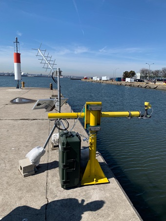
Canada’s Department of Fisheries and Oceans had a number of technologies to choose from, but they eventually settled on the reliability and the accuracy of radar. Radars emit radio microwaves from the antenna system of the sensor. Those microwaves are then reflected off the surface of the lake, and the time of flight from emission to reception is used to calculate the distance, which is then output as the lake level.
The government entity is using a VEGAPULS 61, a sturdy sensor with a fully encapsulated antenna system, ensuring a maintenance-free operation, even as it’s withstanding the constantly-changing weather of the region. As the sun is shining down on the lake and the radar in the summer months, the electromagnetic waves emitting from the radar remain unchanged due to any difference in temperature between the radar and the lake’s surface, providing unwavering accuracy. Plus, advanced electronics prevent any measurement errors caused by snow and ice build-up on the antenna in the winter. Once the VEGAPULS 61 radar was installed and set up, Fisheries and Oceans employees only needed to monitor the data and take appropriate actions to continue their natural resources management efforts.
Export this article
Download as PDFShare this article
Comments ({{comments.length}})
{{getCommentAuthor(comment, "Anonymous")}} {{comment.timestamp | date : "dd.MM.yyyy HH:mm" }}
{{comment.comment}}